Before and after
Drag across the sheet. Rev 0 on the left is the original. Rev 1 on the right has the new work. Property lines, the house, the slabs and the septic system are where they were.
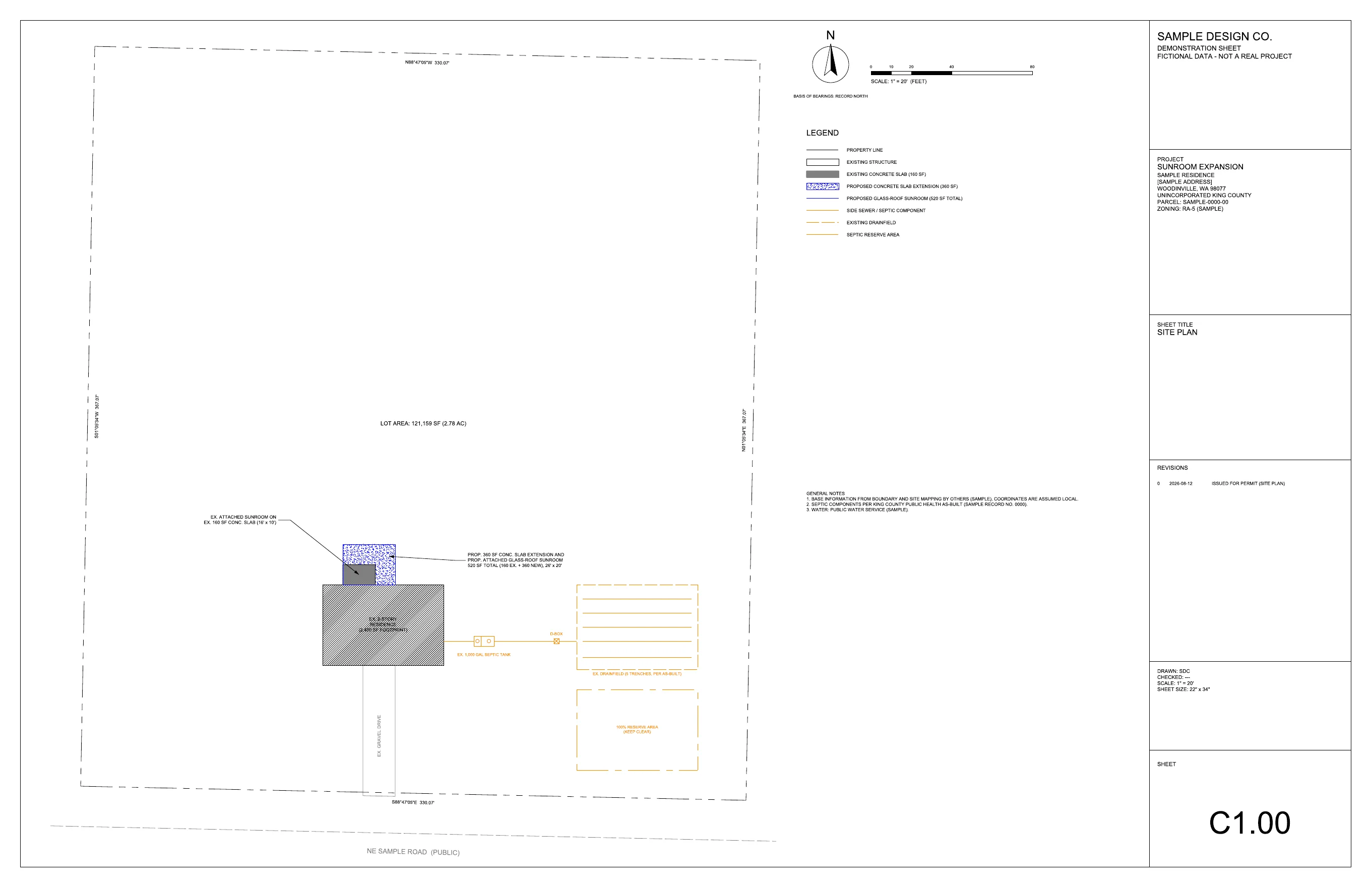
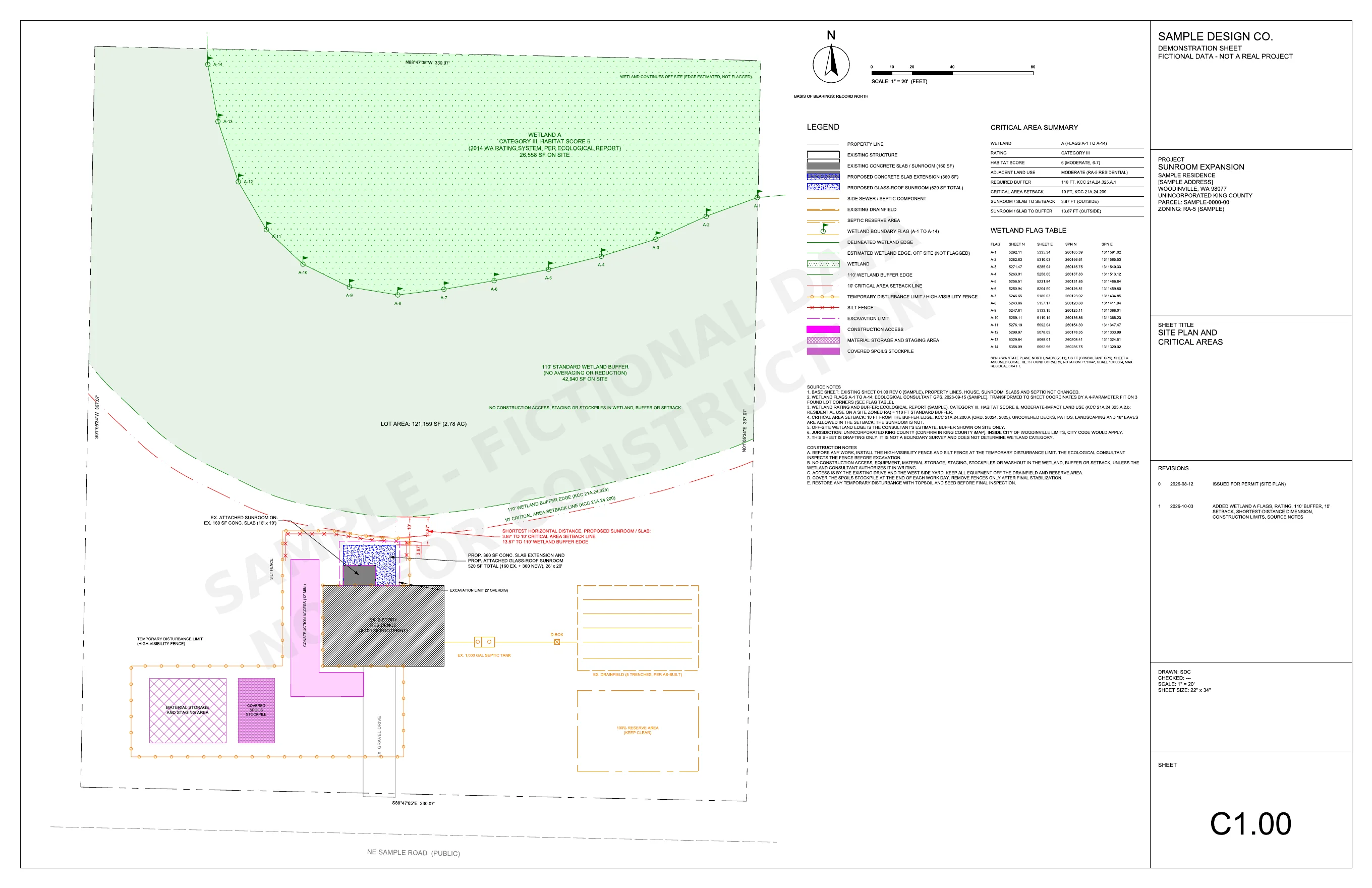 Rev 0 · originalRev 1 · updated
What Rev 1 shows
| Item | On the sheet | |
|---|---|---|
| Wetland boundary and flags | Flags A-1 to A-14 joined as the delineated edge. A flag table gives each point in sheet coordinates and in the consultant's State Plane values. Off site, the edge is an estimate, so it is dashed and labeled as not flagged. | ✓ |
| Wetland rating | Category III, habitat score 6, from the ecological report. | ✓ |
| Buffer | 110 ft standard buffer under KCC 21A.24.325 (Category III, moderate habitat score, rural residential lot). No averaging or reduction. | ✓ |
| Critical area setback | 10 ft past the buffer edge under KCC 21A.24.200, as amended in 2025. | ✓ |
| Shortest distance to the sunroom and slab | 3.87′ to the setback line and 13.87′ to the buffer edge, dimensioned along the shortest line. | ✓ |
| Construction limits | Construction access uses the driveway and the west side yard. The sheet shows a 2 ft excavation overdig, a staging area and a covered spoils pile. The temporary disturbance limit is fenced with high-visibility fence and silt fence. Nothing sits in the wetland, buffer or setback, and equipment stays over 100 ft from the drainfield. | ✓ |
| Base sheet items | Property lines, house, existing sunroom, existing 160 sf slab, new 360 sf extension (520 sf total), septic tank, D-box, drainfield and reserve, north arrow, scale, legend, source notes and revision block. | ✓ |
Close-ups
Click a panel to see it at full size.
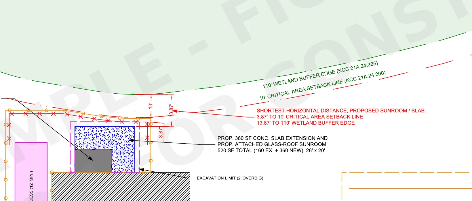
Distance to the sunroom and slab
Measured from the corner of the new sunroom. The numbers on the sheet match the drawing file.
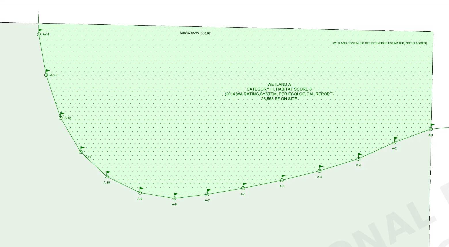
Flags A-1 to A-14
The consultant's GPS points were fit to the sheet using three property corners they also shot. The largest error is 0.04 ft.
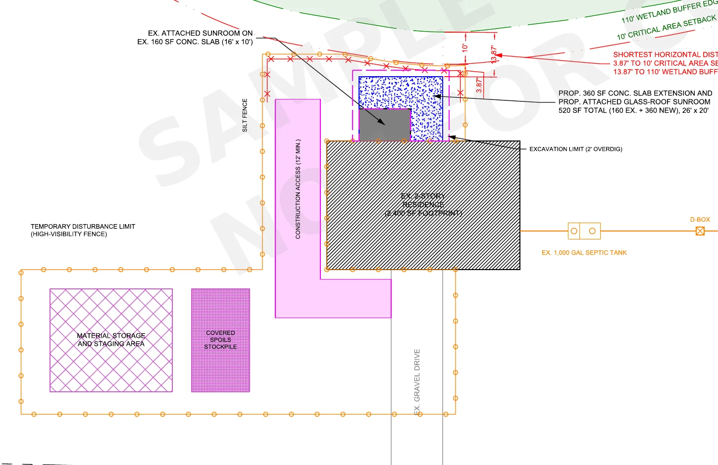
Construction limits
Access, staging and the spoils pile are on the side of the house away from the wetland.
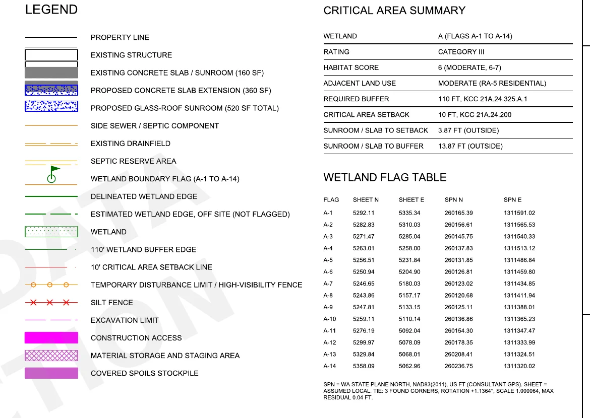
Legend, summary and flag table
The rating, the buffer basis and the flag coordinates are all on the sheet.
The setback changed in 2025
Ordinance 20024 cut King County's structure setback from 15 ft to 10 ft past the buffer edge (outside shoreline jurisdiction). Many older templates still use 15 ft.
The sunroom is 13.87 ft from the buffer edge, 3.87 ft clear of the setback.
The same sunroom would be 1.13 ft inside the setback.
How the update is done
Work in the existing DWG
New work goes on its own layers. Existing linework is left alone.
Tie the flags
GPS flag points are fit to the sheet through property corners, with the residuals reported.
Use the report's numbers
Category and buffer come from the ecological report. We check them against the code table.
Draw and measure
Buffer and setback are offset from the flagged edge. Distances come from the drawing.
Lay out construction
Access and staging stay out of the critical areas and off the drainfield.
Check and send
Areas, distances and overlaps get checked. You get a DWG and a PDF.
QA checks
Measured on the finished drawing.
| Check | Result | |
|---|---|---|
| Flag tie to 3 property corners | max error 0.04 ft | PASS |
| Existing slab / extension / total | 160 sf / 360 sf / 520 sf | PASS |
| Sunroom and slab to setback line | 3.87 ft outside | PASS |
| Sunroom and slab to buffer edge | 13.87 ft outside | PASS |
| Construction inside wetland, buffer or setback | 0 sf | PASS |
| Construction outside the lot | 0 sf | PASS |
| Construction access to drainfield and reserve | 106 ft | PASS |
| Drainfield / septic tank to wetland (WAC 246-272A, reference) | 156 ft / 176 ft | PASS |
| DWG opens and reads back | 406 of 406 entities, 0 errors | PASS |
What's needed to start
- The current C1.00 DWG, with xrefs and title block
- Flag coordinates (CSV or table) and the datum they're in
- Any property corners the consultant shot
- The ecological report
- The septic as-built
- Where the contractor wants access, staging and stockpiles
- Whether the parcel is in unincorporated King County or inside Woodinville city limits
Code: KCC 21A.24.325 (wetland buffers) and KCC 21A.24.200 (critical area setback, Ord. 20024,
2025), checked 2026-10-03 · Rating system: Washington State Wetland Rating System for Western Washington,
2014 update
Sample data. This is drafting work. It is not a boundary survey or a wetland rating.